Salem's Growth Corridors: Where the City Is Expanding
Salem is not growing equally in all directions. The inner belt, from Fairlands to Hasthampatti to the junction area, is largely built out. Four outward corridors are moving: new approvals, highway investments, and institutional anchors have arrived on each of them in the past two years. Here is what is actually happening on each road.
Last verified against government sources on . We re-check this post whenever rules change.
In this guide, you'll learn
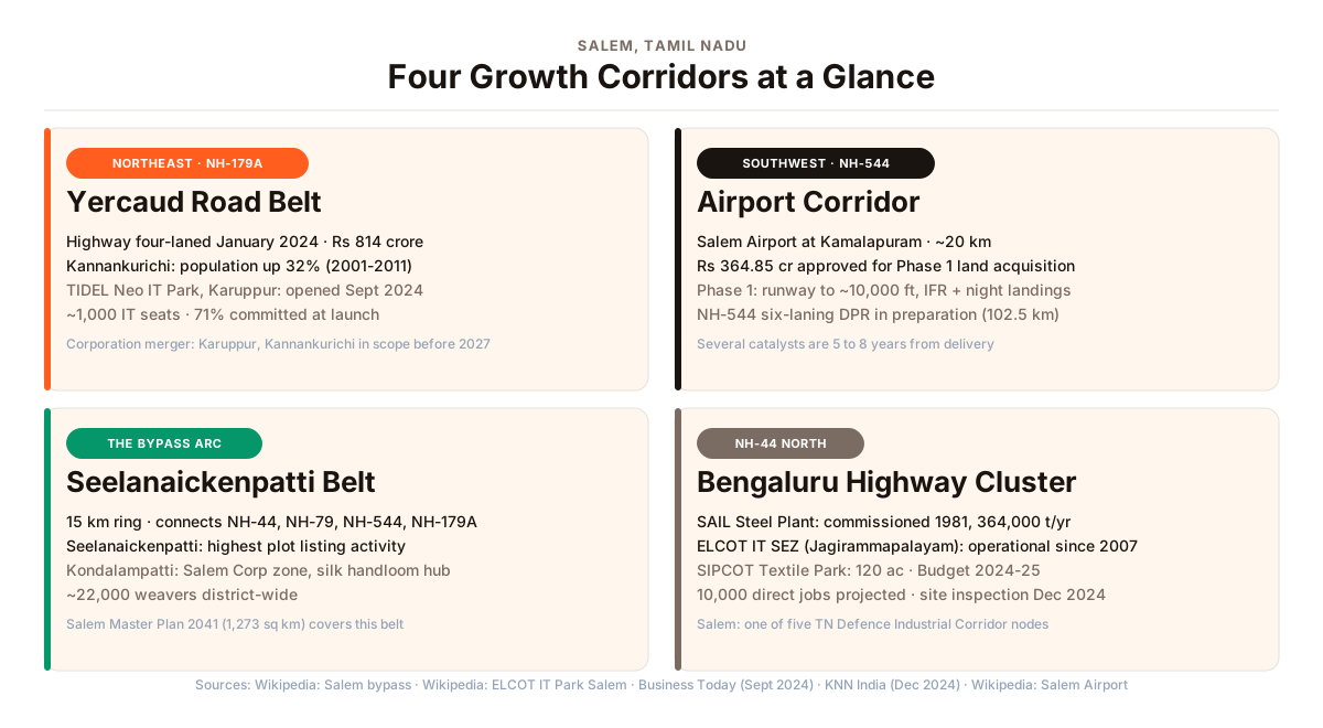
- Salem's four main growth directions each have a different driver: the Yercaud Road belt (NH-179A, northeast) draws families for its scenic foothills setting, a newly four-laned highway, and the TIDEL Neo IT Park at Karuppur that opened in September 2024; the bypass arc through Seelanaickenpatti and Kondalampatti connects four national highways; the airport corridor on NH-544 (southwest) has a funded airport expansion; and the NH-44 north corridor toward Bengaluru has Salem's steel and IT employment cluster.
- The NH-179A connecting Salem to Vaniyambadi was four-laned in three stretches (Km 17.8 to Km 125) at a combined investment of over Rs 814 crore, inaugurated on January 2, 2024. This improvement directly covers the Kannankurichi-Karuppur belt.
- Karuppur, in Omalur Taluk, received a TIDEL Neo IT Park in September 2024: 55,000 sq ft, approximately 1,000 IT seats, approximately 70% occupied at launch. A SIDCO Women's Industrial Park is also in Karuppur.
- Salem Airport at Kamalapuram (NH-544, about 20 km from city centre) has Rs 364.85 crore approved for Phase 1 land acquisition for a runway extension. A Detailed Project Report (DPR) is being prepared to six-lane NH-544 from Chengapalli to Salem (102.5 km).
- The ELCOT IT Special Economic Zone at Jagirammapalayam on NH-44 (4.9 km from Salem Junction) has been operational since 2007. A SIPCOT Integrated Textile Park (120 acres, projected 10,000 direct jobs) was announced in December 2021 and carried forward in successive state budgets, with a ministerial site inspection in December 2024.
- Salem Corporation (currently 91 sq km) is in the process of absorbing four town panchayats, including Karuppur and Kannankurichi, before the 2027 urban local body elections. When a panchayat is absorbed, residents gain formal municipal services: roads, drainage, street lighting, and water supply.
Salem is not growing equally in all directions. The older inner belt, from Fairlands to Hasthampatti to the junction area, is largely built out. It is the periphery that is filling in: new highway investments, institutional anchors, and formal planning activity have arrived on four distinct outward corridors in the past two years.
This is not a guide on where prices are headed. It is a factual map of where Salem’s growth is actually showing up, based on documented infrastructure investment and government planning as of 2024 and 2025.
How Salem Grows: The Basic Shape
Four national highways radiate from Salem: NH-44 runs north toward Bengaluru and south toward Namakkal; NH-544 heads southwest toward Coimbatore; NH-79 goes east toward Attur and Ulundurpettai; NH-179A goes northeast toward Vaniyambadi and the Andhra Pradesh border. These highways are the arteries of the city’s outward growth.
The Salem bypass, a 15 km ring road from Ammapet to Kandhampatti, connects all four highways and defines the edge of the current urban footprint. The corridors described below are the outward spokes from that ring.
Salem Corporation’s current area is 91 sq km, unchanged since the city received corporation status. The state government is working to expand the corporation limits before the 2027 local body elections by absorbing four town panchayats, including Karuppur and Kannankurichi, and 44 village panchayats. A town panchayat has fewer civic resources than a city corporation. Absorption typically brings formal drainage, road maintenance, street lighting, and water supply to streets that currently manage without them. That expansion front defines the growth edge as much as any single project.
Northeast: The Yercaud Road Belt
NH-179A runs northeast from Salem through Hasthampatti, past the city’s built-out edge, and up toward the Shevaroy Hills and the Yercaud hill station before continuing 141 km to Vaniyambadi. This corridor suits families who want a quieter, more scenic edge of the city while staying within reach of Salem’s hospitals and schools.
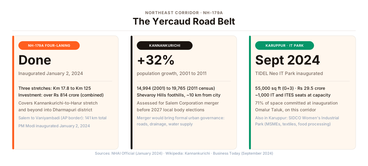
The road was narrow for years, making the Kannankurichi-to-Salem commute slower than it needed to be. On January 2, 2024, the Government of India inaugurated a four-laning project on NH-179A. Three consecutive stretches from roughly the city’s outskirts outward to Km 125 of the highway were widened to four lanes at a combined investment of over Rs 814 crore.
Kannankurichi is the locality that most captures the story of this belt. It sits at the foothills of the Shevaroy Hills, roughly 10 km from the inner city edge. Population grew from 14,994 in the 2001 census to 19,765 in 2011, a 32% increase over that decade. It is among the town panchayats being assessed for merger into Salem Corporation before the 2027 elections, which would bring formal municipal governance to its roads, drainage, and water supply.
For families who want a Yercaud hill backdrop and lower density than the inner city, this belt is worth considering. The trade-off is distance: the inner-city hospital cluster, SKS Hospital and Shanmuga Hospital, is 10-plus km away by road. For families with elderly members who need regular hospital access, that gap matters and should be planned for.
Karuppur, about 9 km from the city in Omalur Taluk, got a significant addition in September 2024. TIDEL parks are state government-built office campuses that attract IT and software companies to Tier-2 cities. The Tamil Nadu Chief Minister inaugurated a TIDEL Neo IT Park here: 55,000 sq ft across four floors, built at Rs 29.5 crore, with approximately 1,000 IT and ITES seats at full capacity. Around 70% of the space was committed at the time of inauguration. The state-run SIDCO Women’s Industrial Park in Karuppur is an older anchor, focused on women-led small businesses in textiles, food processing, and handicrafts.
The Bypass Arc: Seelanaickenpatti and Kondalampatti
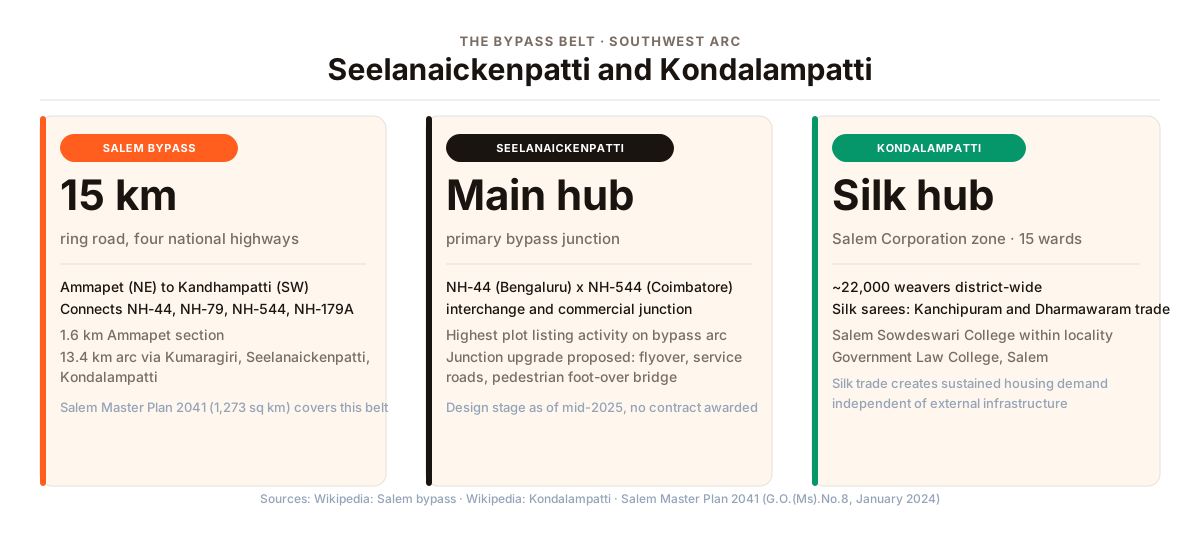
The Salem bypass is a 15 km ring road from Ammapet in the northeast to Kandhampatti in the southwest. Four national highways plug into it: NH-44, NH-79, NH-544, and NH-179A. Almost everything that moves in or out of Salem by road passes through or along this ring.
Seelanaickenpatti and Kondalampatti are the two main junction localities on the arc. Seelanaickenpatti carries the heavier commercial traffic: it is the primary interchange between the Bengaluru highway (NH-44) and the Coimbatore highway (NH-544). A junction upgrade has been proposed here, involving a flyover, dedicated two-wheeler service roads, bus bays, and a pedestrian foot-over bridge. As of mid-2025 this is in the design stage; no construction contract has been awarded.
Kondalampatti has a distinct economic identity. It is Salem’s silk handloom hub: Salem district has a long-established handloom tradition, and Kondalampatti is the commercial and trade centre for the silk yarn and saree business, with connections to markets in Kanchipuram and Dharmawaram. This working population, settled here for generations, means homes in Kondalampatti sell without needing an external project to drive demand. The locality is one of Salem Corporation’s four administrative zones. Salem Sowdeswari College and Government Law College are both within it.
For residential buyers, the bypass belt offers four-highway connectivity, land costs below the inner city, and a position within the Salem Local Planning Area (LPA) Master Plan 2041 coverage area. That plan, notified for public review in January 2024 under G.O.(Ms).No.8, covers an expanded 1,273 sq km planning area that includes these bypass belt localities. It sets the intended land use and density rules for the area, though it has not yet been gazetted as a final order.
One project often mentioned by plot sellers in connection with this belt is the Salem Outer Ring Road Phase 1. The alignment (45.25 km, anchoring at Salem Airport) has been circulated as an option. It has not been formally approved, funded, or tendered. Treat it as a possible long-term upside, not as something buyers should count on in the near term.
Southwest: The Airport Corridor
NH-544 runs southwest from Salem toward Coimbatore and eventually Kochi. Salem Airport at Kamalapuram is about 20 km from the city centre on this road. The airport currently handles flights to Bengaluru, Chennai, Hyderabad, and Kochi, with a single runway of 1,806 metres that limits operations to smaller aircraft under clear daytime conditions.
Phase 1 of the airport expansion is funded and in land acquisition: Rs 364.85 crore has been approved, covering 206 acres total across four surrounding villages. The intended outcome of Phase 1 is a runway extended to about 10,000 feet, which would allow night flights and a wider range of aircraft. Phase 2, further out, would extend the runway to 3,200 metres and build a new terminal.
The main execution risk is a land-acquisition dispute: the four villages surrounding the airport are contesting the acquisition and seeking market-rate compensation. Resolution of this dispute determines the expansion timeline.
The National Highways Authority of India (NHAI) is preparing a Detailed Project Report to six-lane NH-544 from Chengapalli to Salem (102.5 km). The Coimbatore-to-Chengapalli section (54 km) is already a six-lane expressway (no cross-traffic intersections). No investment figure or completion date for the Salem stretch has been published yet.
Engineering colleges on this corridor create steady residential demand independent of the airport expansion. Hindusthan College of Technology is at Sikkanampatty, directly opposite the airport. Student and faculty housing demand from these colleges is ongoing.
North: The Bengaluru Highway Cluster
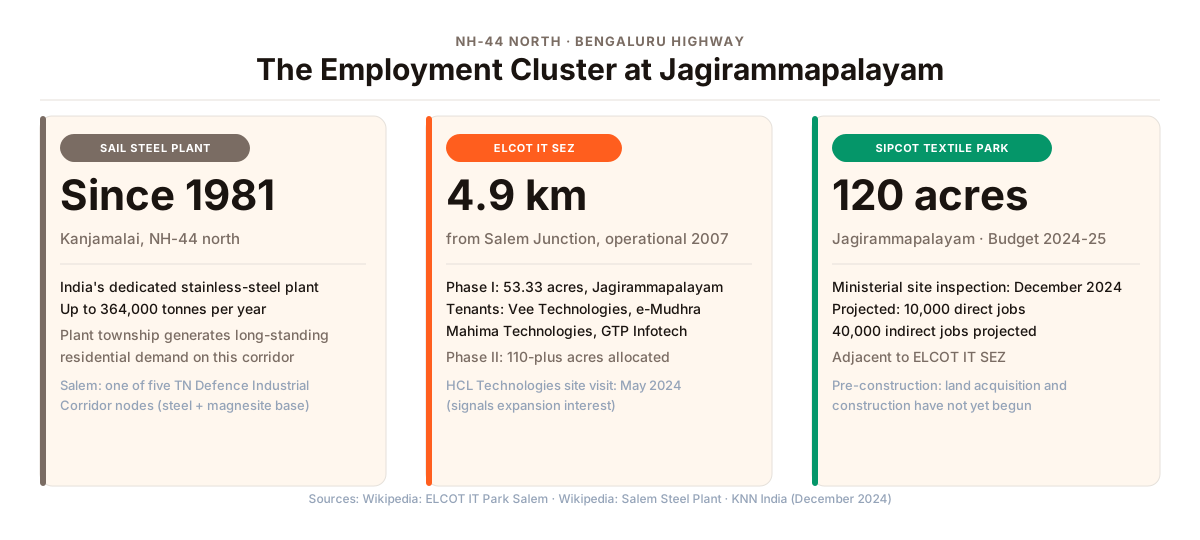
NH-44 running north from Salem toward Dharmapuri and Krishnagiri carries the city’s heaviest industrial concentration. The SAIL (Steel Authority of India Limited) Salem Steel Plant at the foothills of Kanjamalai, north of the city, is India’s first dedicated stainless-steel plant. The plant and its township have been generating residential demand on this corridor for over four decades.
Closer to the city, at Jagirammapalayam (about 4.9 km from Salem Junction), is the ELCOT (Electronics Corporation of Tamil Nadu) IT Special Economic Zone. The SEZ was formally notified in July 2007 and has been operational from around 2010. Phase 1 of the park is 53.33 acres. Tenants include Vee Technologies, e-Mudhra, Mahima Technologies, and GTP Infotech Solutions. Phase II has 110-plus acres allocated. A team from HCL Technologies visited the site in May 2024; HCL has not announced a commitment.
The same Jagirammapalayam locality is the planned site for a SIPCOT (State Industries Promotion Corporation of Tamil Nadu) Integrated Textile Park: 120 acres, first announced in December 2021 and carried forward in successive state budgets. Industries Minister T R B Rajaa conducted a site inspection in December 2024. The projection is 10,000 direct jobs and 40,000 indirect jobs. The park is at the planning and site-assessment stage; it has not yet reached land acquisition or construction.
Salem is one of five nodes in the Tamil Nadu Defence Industrial Corridor, alongside Chennai, Hosur, Coimbatore, and Trichy. Salem’s inclusion reflects what it already has: stainless steel (SAIL), magnesite (Salem district has large magnesite deposits), and power-grid equipment manufacturing.
What This Means for a Buyer
Each corridor suits a different situation.
If established hospitals and schools close at hand are non-negotiable: The inner belt, Fairlands, Alagapuram, and Hasthampatti, is still the clearest answer. Growth corridors trade proximity for lower density and a different character. That trade-off is real and should not be underestimated.
If you want space and a scenic setting, with the city 10-15 km away: The Yercaud Road belt, particularly around Kannankurichi, offers open land, a Yercaud hill backdrop, a four-laned highway, and formal municipal governance coming when the corporation merger goes through.
If bypass connectivity and lower land costs matter more than greenery: Seelanaickenpatti and Kondalampatti sit at the junction of four national highways. Commercial and transit activity is high on the bypass itself; residential streets are behind the junction zones.
If you or your family works on the north side of the city: NH-44 near Jagirammapalayam already has the SAIL steel plant, the ELCOT IT SEZ, and the SIPCOT textile park coming. Employment here predates most of Salem’s other growth stories by decades.
If you are drawn to the airport corridor’s long-term story: The infrastructure logic is sound but most of the headline items are 5 to 8 years out. The TIDEL park at Karuppur and the colleges near the airport are what exist on the ground today.
Each corridor carries projects at different stages of approvals and infrastructure readiness. A corridor’s growth story does not automatically extend to every plot or flat within it. Before buying, visit the site in person: if the roads are mud tracks and there are no electricity lines, the infrastructure is not yet ready, whatever the brochure shows.
Chola Builders has been delivering homes in Salem since 1994, across the city and its surrounding belts. If you want to talk through which part of Salem fits your family’s situation, call us or send a WhatsApp.
For the established inner localities, the area guides for Hasthampatti, Fairlands, and Alagapuram cover each in detail. For a broader picture of Salem’s four administrative zones and how the city fits together, the Salem city areas guide is a good starting point.