How Salem Is Laid Out: A Newcomer's Map
Salem can feel like a puzzle of unfamiliar names when you first start researching it. Fairlands, Hasthampatti, Shevapet, Suramangalam: they all sound close together, but each has a different character. Here is how the city fits together.
Last verified against government sources on . We re-check this post whenever rules change.
In this guide, you'll learn
- Salem sits at the junction of four national highways (NH-44, NH-544, NH-79, NH-179A) and five railway lines, making it one of Tamil Nadu's best-connected Tier-2 cities by both road and rail.
- The city is shaped by hills on multiple sides: Shevaroy Hills to the northeast (Yercaud is here), Nagaramalai to the north, Kanjamalai to the northwest. The Thirumanimutharu River flows through the city, and the old fort area and main temples sit on its banks.
- Salem's commercial heart is Shevapet and the Kottaimedu (fort area) wholesale belt, not the railway station. Salem Junction, despite its name, sits about 5 km west of the commercial core, in Suramangalam.
- Fairlands and Alagapuram, northeast of the Junction along the Saradha College Road corridor, are Salem's most established residential addresses: hospitals, colleges, the new intercity bus stand, and good connectivity all in the same belt.
- Bengaluru is closer to Salem than Chennai is: about 200 km by road versus 335 km. Many Salem families have children working in Bengaluru, which makes Salem an increasingly popular retirement and second-home city.
When you start researching Salem, the area names come at you without context. Fairlands, Hasthampatti, Shevapet, Suramangalam, Kondalampatti: listings use them freely but no one explains how they sit relative to each other, which ones are residential, or where the city actually begins and ends.
This guide gives you one thing: a clear mental picture of how Salem is laid out. Not rankings, not “best area” declarations. An honest map of what each part of the city is, who tends to live there, and how you get from Salem to Chennai, Bengaluru, or Coimbatore.
Hills, a river, and four highways
Salem’s geography is unusual for a Tamil Nadu city. It does not sit on a coast or a broad river plain. It sits in a rough bowl, hemmed in by hills on several sides.
To the north and northeast, the Shevaroy Hills (also called the Servarayan Hills) rise to about 1,620 metres. Yercaud, the hill station, is in those hills, about 30 km from Salem by road. To the northwest, Kanjamalai and the surrounding range shelter the Salem Steel Plant in their foothills. Nagaramalai sits on the city’s northern edge. The effect of all these hills is that Salem stays reasonably cool from November through February, with temperatures dropping to around 16°C on cooler nights, while summers are warm (up to about 39.8°C in May, according to Salem District’s official records at an average elevation of 278 metres).
Through the middle of the city runs the Thirumanimutharu River. It originates in the Shevaroy Hills, flows through Salem, and eventually joins the Kaveri near Namakkal district. It is not a wide river by Tamil Nadu standards, but it shapes the older parts of the city: the old bus terminus and the Kottai Mariamman temple both sit on its banks.
Four national highways converge on Salem. NH-44, the Srinagar-to-Kanyakumari highway (the longest national highway in India), runs north through Salem toward Bengaluru and south toward Namakkal and Madurai. NH-544 heads west toward Erode, Coimbatore, and Kochi. NH-79 goes northeast toward Attur and Ulundurpettai. NH-179A runs northeast toward Harur and the Tamil Nadu-Andhra Pradesh border. For a city Salem’s size, four national highways converging on one point is rare in Tamil Nadu. It is the foundation of Salem’s importance as a trade and logistics hub.
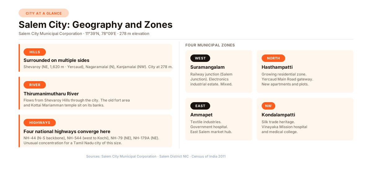
The map below places all the named areas on one canvas so you can see how they sit relative to each other and to the highways.
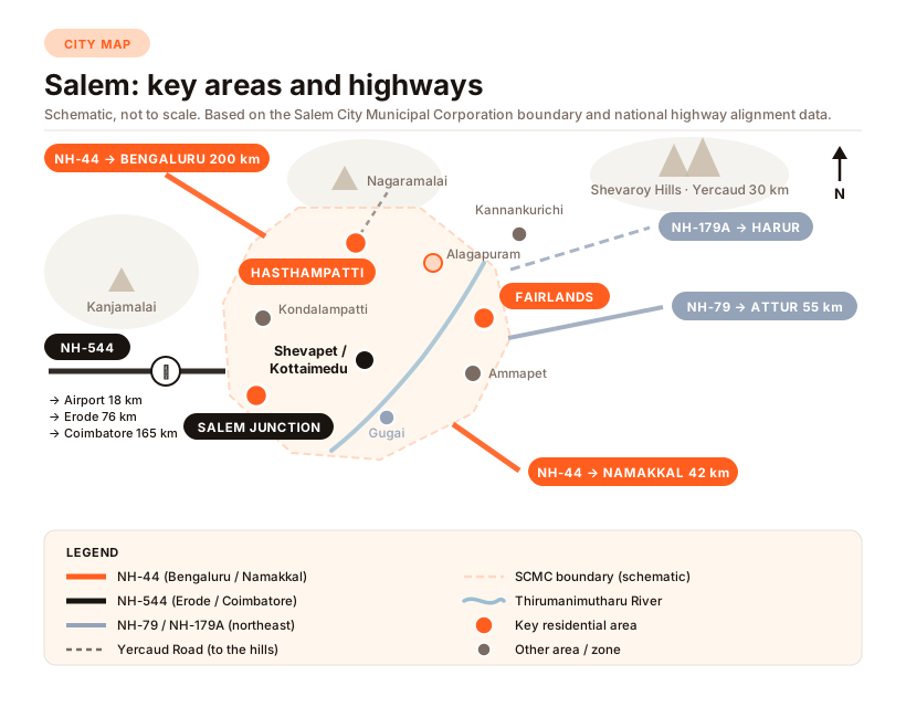
The map is wider than a phone screen. Swipe it sideways to see the whole city.
The commercial heart: Shevapet and the old fort area
The part of Salem that came first is the belt around Shevapet and the Kottaimedu (fort area) quarter. Shevapet is Salem’s wholesale district: gold and silver jewellery, textiles and yarn, food grains and oils, hardware. Merchants from Erode, Namakkal, and the smaller Salem-district towns come here to buy in bulk. The Leigh Bazar is one of the largest wholesale agricultural produce markets in the region. The Leigh Bazar Merchants Association has been formally registered since 1935.
The old fort of Salem, in the Kottaimedu quarter, no longer stands. What remains is the Kottai Mariamman temple, one of Salem’s most prominent places of worship, now located beside the Double Decker City Bus Terminus on the Thirumanimutharu riverbank. The streets around Kottaimedu have the dense, organic character of old fort quarters: narrow lanes, buildings used for both living and trading, no separation between commerce and residence.
For a family evaluating where to buy a home, the commercial core is a reference point, not a residential address. Heavy goods vehicles, loading and unloading activity, and round-the-clock trade make the Shevapet-Kottaimedu belt unsuitable for family living. Most families evaluating a Salem home are looking one or two zones outward from here.
Salem Junction is not the city centre
One fact that consistently confuses newcomers: Salem Junction, the railway station, is not in the commercial core. It is in Suramangalam, in the western part of the city, about 5 km from the Shevapet wholesale belt.
Salem Junction is one of Southern Railway’s more important stations. Five rail lines radiate from it: to Chennai Central, to Coimbatore, toward Bengaluru via Dharmapuri, to Karur, and to Cuddalore. The station reportedly handles around 50,000 passengers a day. Despite the name, “Junction” is a railway designation, not a description of the commercial centre of the city.
The two main bus terminals are also not next to the railway station. The Bharat Ratna Dr. M.G.R. Central Bus Stand is on Omalur Main Road in Angammal Colony, about 3 km from the Junction. The Double Decker City Bus Terminus (the old town bus stand for city routes and shorter services) is on the Thirumanimutharu riverbank near Kottaimedu, about 4 km from the Junction.
Fairlands and Alagapuram: the established residential belt
Ask a Salem resident which area has the most consistent residential character with good hospitals and schools close by, and the answer is usually Fairlands, often followed by Alagapuram.
Fairlands sits northeast of the railway junction, roughly 3 km away. The anchor of the area is the Saradha College Road corridor. Along and near this road: SKS Hospital (a multispeciality hospital operating since 1987), Shanmuga Hospital and the attached Salem Cancer Institute, Saradha College for Women (established in 1961), several schools, and the new Bharat Ratna MGR Central Bus Stand all within reasonable reach. The area is genuinely mixed: commercial activity along the main road, quieter residential streets behind it.
Alagapuram extends the same belt a little further north, toward the foothills of Nagaramalai. It is slightly quieter and more residential than Fairlands. The TNEB (Tamil Nadu Electricity Board) Engineers Colony in Alagapuram suggests a concentration of public-sector families who have made this area their long-term address. The Ismail Khan Lake, a 19-acre water body near the Nagaramalai foothills, gives the area a green character not found in the denser inner zones.
The Fairlands-Alagapuram corridor is where Salem’s established professional and government-employee families have been living for decades. It is not the most affordable part of the city. But for families who want hospitals, schools, connectivity, and a residential neighbourhood feel all in one belt, this is where most Salem families with those priorities end up looking.
Hospitals (SKS, Shanmuga Cancer Institute), Saradha College (est. 1961), new intercity bus stand, good auto and cab connectivity. Salem's most consistent residential address for professionals and government employees. About 3 km northeast of Salem Junction.
Along the Yercaud Main Road. New apartments and plotted layouts developing steadily. Shares the Saradha College Road corridor with Fairlands. Gateway to Kannankurichi at the Shevaroy foothills and Yercaud hill station beyond.
Silk trade heritage. The Vinayaka Mission hospital and medical college on Sankari Main Road anchor residential demand from healthcare workers and students. Primarily plotted layouts and independent houses rather than large apartment projects.
Powerloom industry character from the 1980s expansion. Government Secondary Hospital. Uzhavar Santhai (farmers' market). Functions as a commercial and transit hub for east Salem and the rural belt beyond.
Hasthampatti: the city’s growing north
Hasthampatti is one of Salem City Municipal Corporation’s four administrative zones, running north of the Junction along the Yercaud Main Road.
The area is in a different stage from Fairlands. Where Fairlands is established, Hasthampatti is actively developing. New apartment buildings have come up in recent years. Plotted layouts have been carved out of what were relatively open fields a decade ago. The Yercaud Main Road carries a different feel as an address: the road goes toward the hills, not toward a factory gate.
Nearby sub-localities include Arun Nagar, Ponnandigounder Nagar, MDS Nagar, and Rajarajan Nagar. Saradha College Road runs through the adjoining Alagapuram belt, connecting Hasthampatti to the Fairlands institutional corridor.
Heading further out along the Yercaud Road, you reach Kannankurichi at the Shevaroy foothills. Its population grew by about 32 percent between the 2001 and 2011 Census, reflecting demand from buyers who wanted larger plot sizes and greener surroundings than the corporation limits offer. Beyond Kannankurichi, the road climbs toward Yercaud. Yercaud is more of a weekend and retirement retreat than a place families are setting up a primary home.
Kondalampatti, Ammapet, and the rest
Kondalampatti is the corporation’s northwest zone. It has a historical base in silk yarn trading and manufacturing, with commercial links to Kanchipuram and Arni. The dominant anchor today is the Vinayaka Mission hospital and medical college cluster on Sankari Main Road. The hospital and college together mean there is always a pool of doctors, nurses, students, and visiting faculty looking for housing nearby. Housing in Kondalampatti is primarily plotted layouts and independent houses rather than large apartment developments.
Ammapet is the corporation’s east zone. It has a textile and powerloom character from Salem’s industrial expansion in the 1980s. A Government Secondary Hospital serves the area and the rural belt around it. Ammapet also has the Uzhavar Santhai (farmers’ market) and is partly a transit point for the eastern fringe of the city.
Gugai, south of the old town, is mixed residential and textile-industrial. Families do live here, particularly in streets set back from the main commercial roads, but it is less commonly the first choice for buyers planning a fresh purchase.
Suramangalam, the corporation’s western zone, is home to Salem Junction and an Electrical and Electronics Industrial Estate. It is established rather than fast-growing: railway hub, industrial employment, and residential neighbourhoods together. For buyers whose priority is close proximity to the railway station for frequent travel, the Suramangalam area offers that access.
Four highways out of Salem
The highways define Salem’s connections to the rest of Tamil Nadu and beyond.
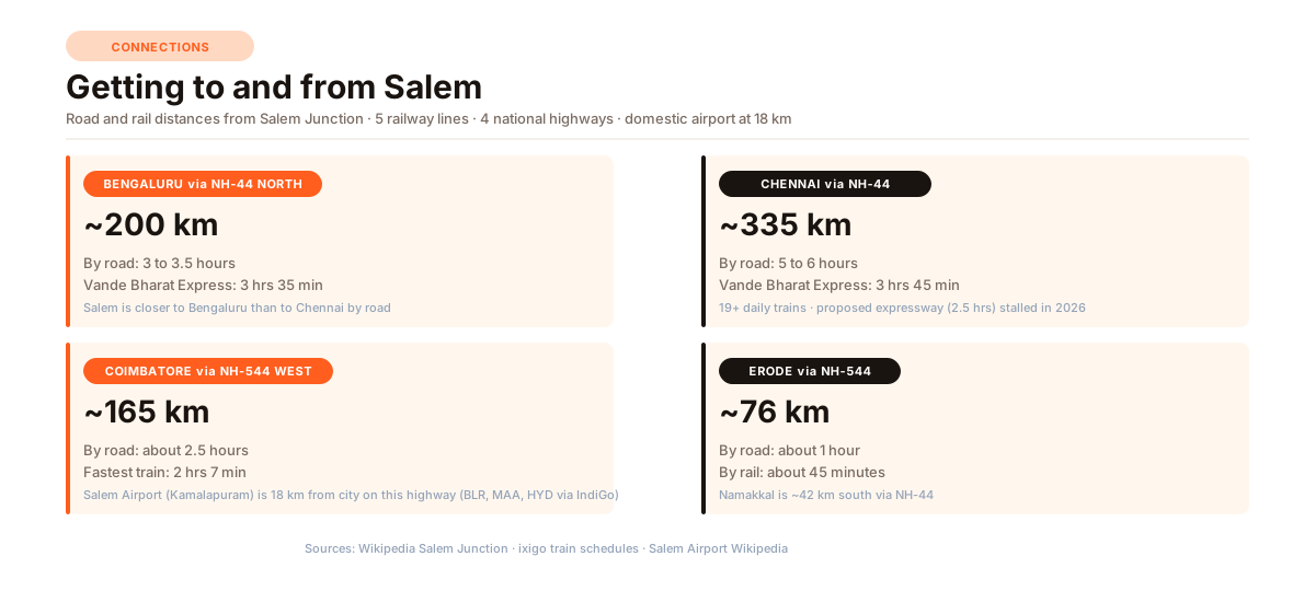
NH-44 north is the Bengaluru road. From Salem, it runs through Dharmapuri (about 75 km), Krishnagiri, Hosur, and into Bengaluru at roughly 200 km. Road travel takes about 3 to 3.5 hours under normal conditions. The ELCOT (Electronics Corporation of Tamil Nadu) IT SEZ at Jagirammapalayam, about 5 km from Salem Junction on this highway, draws IT and technology workers to the city. Many Salem families have children working in Bengaluru, which is one reason Salem has become a retirement and second-home destination for the Bengaluru-connected generation.
NH-44 south goes toward Namakkal (about 42 km), then Dindigul and eventually Kanyakumari.
NH-544 west is the Coimbatore road, running through Omalur (about 18 km), Sankagiri, Erode (about 76 km), Tiruppur, and Coimbatore (about 165 km). Salem Airport is along this western corridor, at Kamalapuram in Omalur taluk, about 18 km from the city centre. The TIDEL Neo IT Park (TIDEL is a Tamil Nadu government IT infrastructure body), opened in September 2024 in the Omalur taluk area, is a second technology employment node on this southwestern corridor.
NH-79 northeast goes toward Attur (about 55 km), Kallakurichi, and Ulundurpettai.
NH-179A northeast runs through Harur, Uthangarai, and toward Vaniyambadi on the Tamil Nadu-Andhra Pradesh border.
A Chennai-Salem Greenfield Expressway (277 km, six lanes) has been announced. When complete, it is designed to cover Salem to Chennai in about 2.5 hours. As of mid-2026, the project has faced legal challenges related to land acquisition and no sections have been completed.
Rail, airport, and bus
By train, Salem is well served. Salem Junction (station code: SA) is the headquarters station of the Salem Railway Division of Southern Railway. Five lines radiate from here. The Vande Bharat Express to Chennai Central takes about 3 hours 45 minutes. To Bengaluru, the Vande Bharat takes about 3 hours 35 minutes. To Coimbatore, the fastest train is about 2 hours 7 minutes. Erode is under an hour away by rail. The station reportedly handles around 50,000 passengers a day and is being upgraded under the Amrit Bharat Station Scheme, a central government programme to modernise major railway stations.
Salem Airport (IATA code: SXV) is a domestic airport at Kamalapuram in Omalur taluk, about 18 km from the city centre on the NH-544 western corridor. Reopened in October 2023 after a period of suspension, it currently serves Bengaluru, Chennai, and Hyderabad. The runway is 1,806 metres, suited to narrow-body aircraft. For international travel or destinations not served from Salem, Coimbatore International Airport (about 165 km away) and Chennai International Airport (about 335 km) are the practical alternatives.
By bus, the Bharat Ratna Dr. M.G.R. Central Bus Stand on Omalur Main Road handles roughly 1,100 buses a day, including services to Chennai, Bengaluru, Coimbatore, Madurai, Kochi, and destinations in Andhra Pradesh and Karnataka. A city bus (Route 13) runs 24 hours between the bus stand and Salem Junction.
Which area suits your family?
Families come to Salem for different reasons. A few patterns that come up often:
If you want a well-established neighbourhood with hospitals and schools close by, Fairlands and the Saradha College Road belt are the natural match. The hospitals and colleges in this belt have been there for decades. The infrastructure followed the institutions.
If you want a newer apartment in a growing area, Hasthampatti and the Yercaud Road belt offer that combination today. Roads and utilities are still catching up, but new apartments keep coming and that is not likely to reverse.
If you want a plot with room to build your own home at prices that reflect distance from the city centre, Kannankurichi at the Shevaroy foothills gives you greenery and more space. You are about 30 to 40 minutes from central Salem by road.
If proximity to the Bengaluru corridor matters for family or work reasons, the northwest belt along NH-44, including the ELCOT IT SEZ area near Jagirammapalayam (about 5 km from Salem Junction), is where IT and technology employment is anchored in the city.
If senior living is part of your thinking, Fairlands and Hasthampatti both have reasonable hospital access. Vilva Homes has built Maghilvanam, a dedicated senior-living community in the Salem area, for buyers specifically planning for that stage of life. Start with what senior living is (and is not) in Tamil Nadu so a 55-plus campus is not mixed up with an old-age home, then senior living in Salem for the city, then what to look for in a senior living community before a site visit.
Salem makes more sense once you have driven it. The city spreads north and west from the old wholesale core around Shevapet, with the residential belt stacking up along the Yercaud Road. The hills are the north wall; the highways are the exit routes. That is the basic shape of it.
Drive the Saradha College Road belt one evening and the Yercaud Main Road the next morning. The layout becomes obvious.
Chola Builders has been building homes in Salem since 1994. If you are evaluating which area suits your family, call us or send a WhatsApp message.
If you are also working through a property purchase in Salem, our guide on patta, chitta, encumbrance certificate and guideline value covers the key documents every Tamil Nadu buyer should verify. For apartment-specific questions about the area you are actually paying for, our guide on carpet area, built-up area and super built-up area explains what the three terms mean and which one matters.